Why We Must Fight Against the Gerrymandered Legislative Reapportionment Commission Map
Bucks County has a strong history of voter engagement and the voter’s will determining who represents you in Harrisburg. You can help keep your voice strong and independent by providing comments to the Pennsylvania Legislative Reapportionment Commission (LRC).
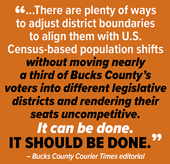 |
As the Bucks County Courier Times editorialized: “The commission that's drafted the Pennsylvania House of Representatives' new legislative districts has done Bucks County voters a grave disservice. We have six days to tell it so.”
You can read the whole editorial here.
The LRC is currently in the final stage of the 30-day public comment period on the draft PA House District map, which the commission passed by a partisan 3-2 vote in December. The public comment period ends next week on Jan. 18. You can submit your thoughts and comments here.
You can also download the maps in this email for uploading to the LRC’s comment section.
While the process used to develop this new map raises many questions, I want to focus solely on the proposed map’s demographic changes.
First, the proposed map unprecedentedly displaces almost one-third of Bucks County’s population into different legislative districts, affecting over 211,000 residents, while making the vast majority of these legislative districts uncompetitive in future elections.
Why Does Being Competitive Matter?
For the last handful of years, we have heard from “citizen groups” such as Fair Districts PA and read media accounts of the need to end “gerrymandering.” Fair Districts specifically opposes gerrymandering because your vote counts less, there are fewer options at the ballot box, and new faces and new options are kept out of office or discouraged from running because districts are drawn for a particular political party. We agree, and without public intervention and media pressure the next five state legislative elections will bear out this grim forecast.
The draft map is gerrymandered at unheard of levels. One party is packed into three districts that the other party will find unwinnable and likewise, the other party will have five districts that they control on paper and most likely will eventually win at the ballot box.
For example, the 143rd District (the 611 corridor from Doylestown north) has flipped between parties the last three election cycles. As drawn in the draft map, a Democrat is unlikely to win the district. Likewise, the 178th District (Northampton Township east to the river) has flipped between parties in the last several elections but is also likely unwinnable for a Democrat as drawn.
Think about that. The last two seats in Bucks that have flipped between the parties at the will of the voters have been gerrymandered to the point that will be dominated by one party.
Here is the LRC Draft Map.
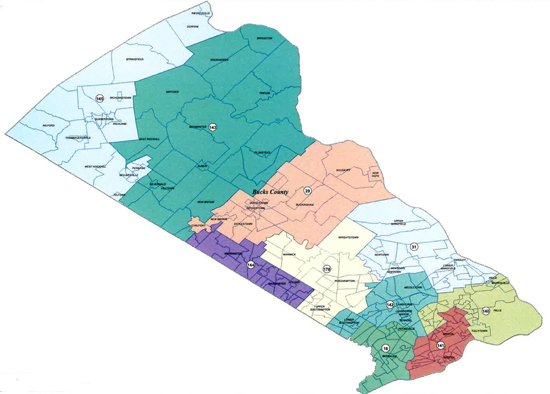 |
| view larger |
This population displacement will disrupt the work being done by current state representatives for constituents, it moves local government and community groups away from the representatives they’ve known and worked with and drops a candidate unknown to the people into their district to be their next representative. This will only breed negative consequences. That’s why many local governments have passed resolutions opposing the LRC map.
Presently, seven of Bucks County’s 10 legislative districts are competitive either through election results, party registration or both.
The LRC map will result in eight noncompetitive seats-- five safe seats for one party, three safe seats for the other, and two seats that lean toward the party with the five safe seats. The Princeton Gerrymandering Project gives the LRC Draft Map an “F” in competitiveness and notes “it is uncompetitive relative to other maps that could have been drawn.”
Naturally, geography and party registration sometime make legislative districts lean toward one party or be completely uncompetitive for another. But in Bucks County, the majority of legislative districts are competitive, which gives the voters the final choice on who represents them in Harrisburg.
In uncompetitive districts, the majority political party’s endorsed candidate almost always wins the primary, then takes the House seat with voter having little say or choice. Bucks County as redrawn in the LRC map will be predominately represented by candidates selected by the majority party of each district, silencing the voice of the people.
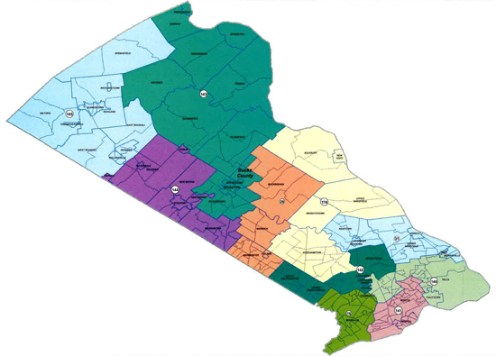
The Current Map
Constitutionally, when redrawn, the legislative maps are to be compact and contiguous, with as nearly equal population as practicable, while discouraging counties and municipalities from being split unless absolutely necessary.
In 2012, the Pennsylvania Supreme Court recognized that “equality of population is the overriding objective” but recognized a “recalibration” allowing a more balanced approach to the other factors.
The current legislative district map that went into effect for the 2014 election after several years of litigation and was ruled constitutional. Bucks County during the drawing of the current map had a population that fell within the constitutional population deviations to have ten house districts within the county boundaries without the need to split Bucks or absorb population from another county.
Here’s the current Bucks County House District Map.
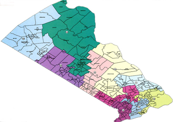 |
| view larger |
Based upon the 2020 Census Bucks County has slightly more than 646,000 residents. Based on the 2020 Census state population the target population per legislative district is a little over 64,000 per district. Bucks County once again does not need to be split with another county, and all 10 current legislative districts can fall within the county boundary.
When examining the current legislative district’s 2020 Census population, nine of the 10 districts fall within the constitutionally accepted deviation from 64,000 except for one district, which is slightly more than 67,000.
So with a less than 1% shift in Bucks County’s population, the current constitutional legislative map would again meet constitutional standards and keep the majority of the legislative districts competitive, giving the voting public a true say in who represents them in Harrisburg.
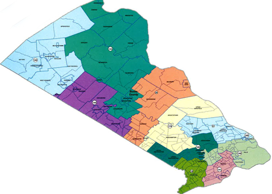
Bucks Map 1A, as seen below, reflects current legislative districts with a slight population shift between two legislative districts to make this map constitutional once again.
When examining the current legislative district’s 2020 Census population, nine of the 10 districts fall within the constitutionally accepted deviation from 64,000 except for one district, which is slightly more than 67,000.
So with a less than 1% shift in Bucks County’s population, the current constitutional legislative map would again meet constitutional standards and keep the majority of the legislative districts competitive, giving the voting public a true say in who represents them in Harrisburg.
Bucks Map 1A, as seen below, reflects current legislative districts with a slight population shift between two legislative districts to make this map constitutional once again.
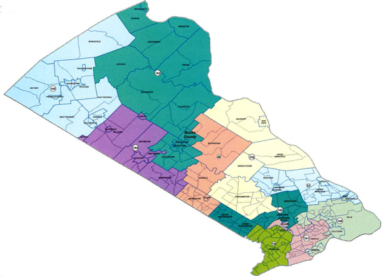 |
| view larger |
A Second Option
Bucks Map 1B, as seen below, takes the existing constitutional and competitive map and addresses the current limited population deviation issue while reducing two municipal splits to further comply with the state Constitution.
The existing constitutional map requires a slight population shift to remain constitutional. It currently contains municipal splits in Bristol Township, Buckingham Township and Morrisville Borough; Middletown Township is split between three representatives. The constraints of trying to remain within the +/- of a population deviation requires some municipalities be split between representatives. The PA Supreme Court has found the current splits to be constitutional.
Conclusion - Map 1B puts all 10 districts within population deviation and eliminates the Bristol Township split and reduces Middletown from a triple split to a split between two representatives, thereby reducing Bucks County’s splits from five splits among four local governments to a total of three splits within three local governments. It also shifts less than 7% of Bucks County’s population while keeping the majority of districts competitive.
A Third Option
Working through the process of map drawing is not an easy one. Bucks County is bound by a river on two sides and working to stay within county boundaries landlocks you to the west and north. The map must be drawn with +/- 64,000 residents in contiguous townships and boroughs while splitting as few as possible to be constitutional. That brings us to compactness, which to some degree is in the eye of the beholder.
The current legislative map was considered compact enough to be constitutional by the Pennsylvania Supreme Court, but certainly is not “pretty.” When you look at municipal boundaries you will find many are not straight and naturally create a jagged edge. Likewise, it takes a lot of smaller population municipalities to get to 64,000 residents without having a population center in a legislative district, which again is contrary to compactness and may result in a district that is not “pretty.”
Conclusion-- Map 2, seen below, is an example of a map that reduces municipal splits by two while creating a new one for a net reduction of one, while shifting population by less than 12% and again keeping the majority of districts competitive. Simply put, the Bucks County map can be drawn several different ways that does not radically displace population and keeps the majority of districts competitive.
Conclusion
As the deciding vote in a 3-2 split on the LRC, the chairman stated that the reason he supported the radical changes in the Pennsylvania maps was because of the populations shifts in regions in Pennsylvania. Bucks County is not one of those regions. We squarely fall within the necessary population growth to remain constitutional with minimal population displacement.
More than 200,000 residents do not need to be displaced while also making all but two legislative districts uncompetitive and leaving 80% of the voting population at the mercy of the political party bosses’ hand-picked candidates. And the last thing we need is more political polarization.
The voters are the firewall that limits political parties from moving to the extremes. By packing the districts for one party or the other, the primaries will dominate the election cycle and you will see more extreme candidates chosen to further erode your representative’s voice.
Can Bucks County end up with a map that shifts population 12% or less, while reducing municipal splits and keeping the majority of elections competitive? YES.
So why didn’t the map end up like one of the maps offered or something similar? GOOD QUESTION
We have until Jan. 18 to make their voices heard.
Submit your comments to the LRC here.
All the maps on this page can be saved and downloaded, then uploaded to the LRC comment section.
Bucks Map 1B, as seen below, takes the existing constitutional and competitive map and addresses the current limited population deviation issue while reducing two municipal splits to further comply with the state Constitution.
 |
| view larger |
The existing constitutional map requires a slight population shift to remain constitutional. It currently contains municipal splits in Bristol Township, Buckingham Township and Morrisville Borough; Middletown Township is split between three representatives. The constraints of trying to remain within the +/- of a population deviation requires some municipalities be split between representatives. The PA Supreme Court has found the current splits to be constitutional.
Conclusion - Map 1B puts all 10 districts within population deviation and eliminates the Bristol Township split and reduces Middletown from a triple split to a split between two representatives, thereby reducing Bucks County’s splits from five splits among four local governments to a total of three splits within three local governments. It also shifts less than 7% of Bucks County’s population while keeping the majority of districts competitive.
A Third Option
Working through the process of map drawing is not an easy one. Bucks County is bound by a river on two sides and working to stay within county boundaries landlocks you to the west and north. The map must be drawn with +/- 64,000 residents in contiguous townships and boroughs while splitting as few as possible to be constitutional. That brings us to compactness, which to some degree is in the eye of the beholder.
The current legislative map was considered compact enough to be constitutional by the Pennsylvania Supreme Court, but certainly is not “pretty.” When you look at municipal boundaries you will find many are not straight and naturally create a jagged edge. Likewise, it takes a lot of smaller population municipalities to get to 64,000 residents without having a population center in a legislative district, which again is contrary to compactness and may result in a district that is not “pretty.”
Conclusion-- Map 2, seen below, is an example of a map that reduces municipal splits by two while creating a new one for a net reduction of one, while shifting population by less than 12% and again keeping the majority of districts competitive. Simply put, the Bucks County map can be drawn several different ways that does not radically displace population and keeps the majority of districts competitive.
 |
| view larger |
As the deciding vote in a 3-2 split on the LRC, the chairman stated that the reason he supported the radical changes in the Pennsylvania maps was because of the populations shifts in regions in Pennsylvania. Bucks County is not one of those regions. We squarely fall within the necessary population growth to remain constitutional with minimal population displacement.
More than 200,000 residents do not need to be displaced while also making all but two legislative districts uncompetitive and leaving 80% of the voting population at the mercy of the political party bosses’ hand-picked candidates. And the last thing we need is more political polarization.
The voters are the firewall that limits political parties from moving to the extremes. By packing the districts for one party or the other, the primaries will dominate the election cycle and you will see more extreme candidates chosen to further erode your representative’s voice.
Can Bucks County end up with a map that shifts population 12% or less, while reducing municipal splits and keeping the majority of elections competitive? YES.
So why didn’t the map end up like one of the maps offered or something similar? GOOD QUESTION
We have until Jan. 18 to make their voices heard.
Submit your comments to the LRC here.
All the maps on this page can be saved and downloaded, then uploaded to the LRC comment section.
Sign Up to Receive Legislative Email Updates
Keep up-to-date on the latest legislative and community news. Your email address will be used strictly for legislative purposes.